Camping at Dry Tortugas National Park
From the first time we visited the Dry Tortugas, Matt and I wanted to camp there. It’s a group of tiny islands 70 miles out into the Gulf of Mexico, with a giant fort and tons of wildlife (and over 90% of it is underwater). Who wouldn’t want to do that? So, once we moved to Key West and figured out the best time of year for camping (the winter, since it’s not that hot), we booked a trip to the Tortugas way in advance.
That’s my first bit of advice! Book your trip way in advance. Also, while there’s a really good locals’ discount on the ferry for day trips, that doesn’t apply if you’re camping. Our trip cost $460 total: $390 for the ferry, $20 each for our kayaks, and $15 per night for camping. You’ll need to bring exact cash for the camping fee, since you put that in the camping box when you arrive. The rest is paid in advance.
You have to arrive at the ferry terminal by 6:30 in order to load your gear before everyone else boards. You can park on the street temporarily right in front of the terminal, and they provide big rolling carts. It took us three trips between the kayaks and our gear, but we did it. Matt went to go park in the ramp while I rolled the rest of the gear down the ramp onto the ferry. The captain was there to assist us.
They say you’re allowed 60lb of gear per person; we were just within that limit and were a little nervous about it. There was no indication they actually checked that, though. Because you have to bring a decent-sized animal-proof cooler (there are rats), ice and enough water for the entire duration of your stay, I feel like they don’t enforce that much. We brought a scaled-back version of all our camping gear, camp chairs, a Rubbermaid tote with food and cooking stuff, plus a hardsided cooler. You’re not allowed to bring propane or anything explosive, so you have to go with charcoal or Sterno. I definitely recommend having Sterno as a backup, for reasons you’ll find out below.
There’s also a chance that if there are high seas or other bad weather, the ferry won’t be able to travel on your return date. So make sure to bring some backup food and water just in case. You can leave any extra water with the other campers, who will be happy to have it. One of the rangers even recommended using it to water the palm trees they’d just planted!
We had a meeting with the captain on the ship, where he checked us in, reviewed the rules, and gave us a couple giant trash bags to use on the island. Included with your trip is breakfast on the outbound trip, and one lunch. Like most people, we opted to have our lunch on the day we were returning, so we could pack up early and not have to cook.
After the meeting, we headed to the boarding area and waited with everyone else. The ferry ride was uneventful until we got to the channel about halfway to the Tortugas, and then the seas got rougher. I was wearing Sea Bands, though, so it wasn’t a problem at all. If you get seasick, GET THEM. They’re amazing.
We got to the dock on Garden Key (the largest of the islands, and the one where Fort Jefferson is) about 10:30am. They asked the campers to all assemble on the top deck for a meeting while everyone else got off the boat. There were seven of us arriving that day: another couple, and a group of three. We were the only ones who were staying for two nights.
Ranger Nick, who was awesome and really funny, reviewed all the camping rules again (mostly about animals, cooking, and being careful walking around at night). He also invited everyone to a fishing class after the ferry left, and told us how to get a hold of them at night in case of emergency. It involved a distress call on a marine radio, and only entering the fort as a very last resort.
We chose this site because it was in a narrow area between the moat and the beach. Seriously, how amazing is this? There were only a few shaded spots in the campground and they were already occupied, but we figured it wouldn’t be a huge deal since it wasn’t that hot. It was, however, VERY VERY WINDY.

The wind made setting up a huge pain in the ass, because everything kept trying to blow away. It was so intense that we grabbed some rocks to put on the edge of the rain fly; we were worried it was strong enough to bend the tent poles. That had actually happened to us before!
Once we had everything set up and had claimed our picnic table, we went for a walk around the island.

We’d been told that Carlos the Crocodile had been seen recently in the moat near our campsite. I didn’t see him there, just this starfish:

Most of the ferry visitors were inside the fort, so we walked down Bush Key.


Here’s the division between Bush Key and Long Key. Long Key is totally off-limits because it’s the only magnificent frigatebird nesting site in North America.

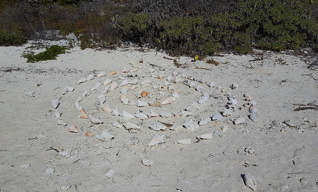
The far end of Bush Key is covered in conch shell trees. I love these.


Conch spiral!
Here’s a washed-up Portuguese Man-of-War. Don’t mess with this guy.


While we wandered, the two seaplanes who service the island were coming and going. It’s awesome watching them landing.

Round about 3pm, it was time for the ferry to go. We went down to the dinghy beach (where our kayaks were hanging out) and watched it go. The guy in the life jacket is one of our fellow campers who had been there the previous night. He had a really nice kayak and what appeared to be the best campsite, hidden in the trees and out of the wind.

The island changes completely the second the boat and last seaplane leave. It suddenly feels very remote. It’s amazing.
Ranger Nick had told us earlier that he was giving fishing lessons once the boat left, so we decided to go check that out. The park has a fishing license that covers all visitors, which is pretty awesome. They also have all the gear there for you to borrow.
He first showed us how to cast a net for bait. It took a few tries, but we got a bucketful soon enough.

Then it was fishing time! There was another couple there from Miami, so they and Matt got hand reels and baited their hooks. I was just there to watch, since as a vegetarian I’m not that excited about possibly hurting a fish.

That changed quickly as Ranger Nick handed me a reel that already had a line in the water. They promised me they’d use the fish if I caught it, so I fished. It was kind of exciting.
It was mostly mangrove snapper under the dock, but there were also some bigger yellowtail hanging around. One of them took my hook and started pulling. Suddenly, a gigantic goliath grouper swam up, ate the yellowtail and ran with the tiny, tiny line on my hand reel.
Ranger Nick helped me let all the line out and then we waited. I had no idea how this was going to end in anything successful, but the gigantic fish stayed on the line for a long time. Finally it went slack, and it was time to try again.
But then I caught a real fish! My first fish ever. It was a just-barely-legal-sized mangrove snapper.

While we were fishing, a big Coast Guard ship came sailing up, with huge guns on the deck and everything. Even the ranger was standing there gawking as they docked. I asked him what was going on, and he said he had no idea – they’d had small Coast Guard boats before, but nothing like this at all. It was kind of bizarre.

Everyone else caught their own fish, and the ranger was nice enough to do the butchering for us. Since the Miami couple didn’t have a cooler, Matt took all the filets back to put in our cooler for dinner. We we all very proud of ourselves. These guys were happy for the guts, too.

It was nearing sunset, so we headed into the fort to climb up to the top of the wall. Fort Jefferson closes after sunset, but the rangers told us we had about 15 minutes to clear the grounds afterwards.
Here’s the lighthouse on Loggerhead Key. It’s about 3 miles away, and in good weather you can kayak there. There was no way that was happening in 30mph winds, though. (We were questioning any kayaking in that weather.)


We had a pretty good view from the campsite. Seriously amazing.

Once the sun went down, we headed to our tent to make dinner. Look at how calm and peaceful it looks in this photo! And check out my Luminoodle lights, which were running on a backup battery that I charged via portable folding solar panel! The wind was really strong, somewhere between 25-30mph, and we had a couple big rocks holding the rain fly down. Those stakes weren’t all that great in the sand.

The wind meant we had some trouble getting the grill going, too. We had a little bag of charcoal per the ferry’s recommendations, but Matt was struggling to even get the lighter to light. We finally made enough of a windblock to make it happen, and put out food on the grill. We had plantains, a veggie dog for me, and of course the fish filets in the cooler. The couple from Miami came over and asked if we minded cooking their fish too; it turned out they had just brought some trail mix and snacks in bags since they were only staying one night. We sat around talking while our dinner cooked very slowly in the ridiculous wind.
They ended up being really great, and had good advice on camping in the Everglades. We all shared our food and sat around being amazed by the stars, which were brighter than we’d ever seen before. They headed back to their campsite after dinner, and we cleaned up and decided to walk over to the group-camp area where it was completely open to see the stars better.
The Coast Guard ship was still docked there, and we realized there were guys coming back from the beach wrapped in towels, boarding the ship. Apparently they had just stopped by for a beach break! You could see general movement and hear the intercom beeping, but we were too far away to hear their announcements. We figured they were going to sail pretty soon, but didn’t seem to be in a huge hurry to do so. We saw the rangers come out and close up the dock building for the night, and then everything became very dark and quiet.
I wish there was some way to capture how the sky looked. There were so many stars we had trouble picking out constellations, because we’re used to only seeing the main stars. (Even in Key West we have a pretty dark night sky – far darker than anything I’ve seen up north – but nothing like this.) The Milky Way was clearly visible overhead, running across the entire sky. It was unreal. (To get an idea of it, watch this video. It give me goosebumps, it’s so accurate.)
After a while, the moon started to rise over Bush Key and the Coast Guard ship. We could see at that point that there was no longer anyone on the bridge, so apparently they were hanging out for the night. We went to use the restrooms and then headed back to our campsite.
A note about the restrooms: when the ferry is at the dock, everyone on the island is supposed to use their restrooms. This is a very good thing, since they have flush toilets and running water to wash your hands. When the ferry leaves, they unlock the composting toilets. They were actually in very good condition and didn’t smell anywhere near as much as usual camping pit toilets. However, if you go in there at night wearing your headlamp, don’t shine it down into the toilet. The cockroaches running around in there won’t make you very happy about the whole situation.
It was pointless to try to sit up and play a game with the wind, so we climbed into the tent and read Kindles for a while. The wind made it extremely loud, with the rain fly whipping against the tent. (Matt was convinced we’d have been better off without it, but I thought it would be loud regardless. Plus there was a chance of rain.) We both slept miserably; I kept waking up with the side of the tent would blow against my head, and I’d have to scoot down and sleep in a ball. It wasn’t pleasant at all.
The next morning, I got this view on the way to the bathroom. I wasn’t that mad about not having slept much, seeing this.

The Coast Guard ship had sailed off a bit earlier; we heard their intercom and the engines starting up. That meant there were maybe 20 of us total on the island, including the park rangers. Amazing.

Here’s South Beach. It’s different from the Miami version.

I don’t think I’ve ever been the first person to leave footprints on the beach in the morning.

On the way back to our site, I passed the kayak-guy, who was making breakfast over a can of Sterno. I told him about our travails in the wind and difficulty cooking, and he told me that he was going to be heading back that day, so we should claim his site and move the tent. He said he didn’t notice the wind at all, because he was hidden in the trees. It was definitely the best site in the campground.
He also said that Sterno was the way to go in the wind, and gave me the little grill he was using to cook on. He said to take it and bring back a bag or something to put at his site so that everyone knew it was ours. I loved that guy a lot, because he was 100% right.
We gathered our things and prepared to move. The turkey vultures didn’t waste any time looking for leftovers by our picnic table.

This is what our new site looked like. It was a HUGE improvement.

Since we had also brought Sterno per the ferry’s recommendation (mostly because we didn’t want to heat coals for breakfast), we were able to quickly rig up a windblock with bricks and the guy’s little Sterno stove and had a much more pleasant cooking experience than the previous night. Blueberry pancakes! They were delicious.

One of the seaplanes arrived while we were having breakfast and moving camp, and then the ferry. We decided it was time to get off the island while all the people were on it.
Our kayaks had been hanging out at the dinghy beach, so we were ready to go. We had a chat with our kayaking pal about conditions; he said it was pretty difficult paddling due to the wind, but told us which route to take, sticking to the shore. We geared up and paddled out.

Our kayak pal had boarded the ferry at that point, and was up on the top deck waving at us as we passed. The paddling didn’t seem too difficult at all, since the land curves around and blocks most of the current coming in from the channel. We just got splashed a bit.
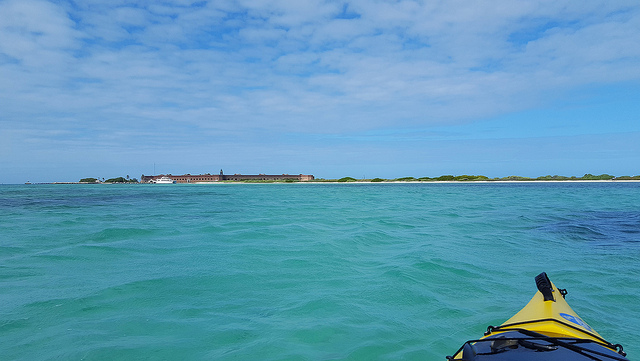
Here’s Fort Jefferson and the ferry from the water. I still can’t get over this place. It’s amazing.
We paddled along Bush Key, and then crossed the little channel between that and Long Key. Much of the sand spit was above water, so it was doing a good job of breaking up the current. Still, it was the most difficult area to paddle in.
Long Key is surrounded by buoys marking the do-not-cross line. This is the closest we could get to the magnificent frigatebird nesting grounds, but we were close enough to see them in decent detail. There were hundreds of them, and eventually we were able to pick out some of the males sitting in trees puffing out the giant red sacs on their neck that they use for a mating display. Hilarious.

After watching the birds for a while, we paddled back toward Garden Key.

We went over to the far side of the dinghy docks, where an old platform used to be. The pilings were full of pelicans and seagulls, so we stirred them up a bit. Our Miami friends were hanging out there by the water, so we wished them a good trip back on the ferry.

The paddling was much harder the closer we got to the South Beach side, so we headed back to the dinghy beach and pulled up our boats. We were very happy that we hadn’t brought the kayaks in vain, because we were convinced it wasn’t going to happen in that wind. We’d have to save the Loggerhead paddle til next time!
We took advantage of the ferry’s clean restrooms and running water several times that day. It was especially convenient after lunch, when everyone clears out and heads into the fort for the tour. (If you’re out of water, ice, etc you can purchase it on the ferry, too. It’s just really expensive, so plan ahead!)

We went back to the campsite to make some lunch. As other campers had mentioned, the ground now looked like it was moving because of all the hermit crabs. They were adorable.

We had to be really careful walking around, though. I’d be sad to mash one of those little dudes. If you dropped food, a bunch of them would go swarming toward it and a hilarious crab battle would ensue. Usually the biggest guy won; his name was Lawrence Whelk. (I know.)

After lunch, the fort had emptied out quite a bit and a lot of the daytrippers were back on the ferry. We decided to go tour it again. It was nice to feel like you could take your time with everything; when you’re on the ferry or seaplane, you’re aware of just how limited your time is on the island.
This never gets old:

Closeup of the floor; the concrete is full of shells and coral.

Hard to see, but there are snorkelers along the wall. They’re much braver than we are, since the water was REALLY COLD. January is not swimming time in the Keys, no matter what people tell you.

Here’s the view from the front of Fort Jefferson.

Looking toward the campground (in the trees).

Bally likes to pretend he’s a cannonball. Of course Bally came with us to the Tortugas!

Looking through the fort to the north:

And there are our kayaks hanging out on the beach.

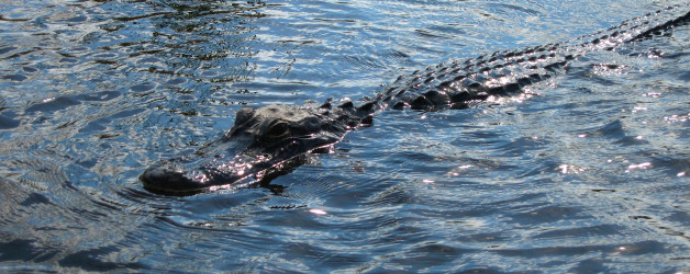
When we got back to the campground, a guy was standing near the moat staring at something. We went to see, and he pointed out Carlos the crocodile. He was so well-camouflaged it was hard to see him, but he’s there. Look to the bottom right of the rusted piece of metal near the water line and his head is there. His tail is mostly in the water.

So yeah, there was a crocodile within view of our campsite. We weren’t especially concerned about it since he’s there a lot (and crocs aren’t aggressive like alligators can be), but other people were. We learned that he swims miles to some of the other keys to look for food and ladies!
The ferry headed out and the seaplanes were leaving shortly, so we grabbed a blanket and our Kindles and headed over to North Beach. There’s a lot of fascinating old stuff to see at that beach; there’s a pile of mechanisms from the fort, and old worn bricks all over the place. We had the beach to ourselves just like we did the first time we visited!

Here’s something that’s changed in the year and a half since we moved to Key West:

We hung out reading and staring at the ocean for a while, and then decided to head back to the campground. We took our chairs to the beach and joined most of our fellow campers there to see the sunset.

This view never gets old. I love it.

The wind was still in full force; I felt a little bad for the people who had claimed our old campsite. However, at our new site, we barely even noticed it. It was such a huge difference, it was amazing. We set up our lights and made dinner over charcoal.
My Luminoodle lights worked perfectly, and I had charged all our battery packs during the day with the solar panel mounted on the post for hanging trash. I had a set of four little USB backup chargers that were plenty to keep our campsite and tent Luminoodles running, and our phones fully charged. (Even though there’s no cell service at the Tortugas, you obviously have to take a million pictures.)

We played cards for a while, and ended up going to bed pretty early because of our prior sleepless night. We had the rain fly on the tent mostly because it’s entirely mesh and I didn’t want someone walking by and looking at my naked butt in the morning. We left the side doors open, though, and with a slight breeze it was incredibly pleasant.
I got up shortly before sunrise, and was greeted by a completely deserted island. I didn’t even see rangers walking around at that hour.

I watched the sun come up over the Gulf, still having my mind blown at the fact we got to stay there. It’s so incredible.

We got up, made breakfast, and started packing up camp. I talked to a few people about their campsites, and they were uniformly miserable because of the wind. Like our previous camp-tenant, we told them to consider taking over our site when we left. There are only 2-3 totally sheltered sites there, and they make a huge difference in either sun or wind.
The red flag was flying on the fort, indicating that small boats were allowed to come into the harbor and moor for wind shelter. There were several sailboats tied up there.

We grabbed a rolling cart from the dock and started hauling our stuff over. You’re supposed to have all our gear waiting in the pickup spot on the dock by 10am, as well as all your trash so they can haul it back to Key West. While they supply giant, heavy plastic trash bags that work well for hanging up away from pests – palm rats, mostly – they don’t have any recycling receptacles for your campsite. We just threw all our recycling in our cooler to haul back with us. (I think they also had recycling on the ferry.)
These turkey vultures supervised as we hauled our kayaks to the dock.

They’re incredibly graceful-looking creatures in the air, and stupidly gawky on land. They’re really entertaining. (They also know where the fish scraps come from.)

When the ferry arrived, they quickly offloaded the new campers’ gear and put ours onboard. Here are our kayaks, ready to go!

We kept a day bag with us, since we had til 3pm on the island. We did some more reading on the beach, then grabbed some lunch from the ferry and had a picnic. After that, we joined the short tour of the fort to see if we’d missed any important knowledge about it (we had, too!). We went to have a chat with the guy who ran the visitor’s center, since Matt had met him the previous day, and then did some more wandering around the fort. We swore there were different areas open than we’d seen previously, which is definitely possible since it’s always under renovation. I don’t recall ever seeing Samuel Mudd’s cell before – it’s directly above the visitor’s center on the second level of the fort.
And then it was time to head back to civilization, sadly. The ride back was rough again, but SeaBands got me through.
Now I want everyone to do this same trip so we can compare notes on how amazing it is!


 horse tongue!